Independent Intelligence Layout for Maneuvering Forces
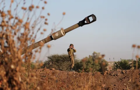
In an era where enemy targets only become visible for a few seconds, the IDF fire support layout endeavors to minimize the information gap between the maneuvering elements and the command echelons. One of the solutions proposed by IAI is a UAV-based intelligence gathering system
Ami Rojkes Dombe
| 23/11/2016

Photo: IAI
One of the primary characteristics of today's ground theater is an intelligence time lapse between the information available to the maneuvering elements on the ground and the 'operationalization' of the intelligence being collected and subsequently disseminated by the command echelons. This time lapse contradicts the trend where the intervals during which the forces on the ground may respond to the threats are becoming progressively shorter. In an era where enemy targets only become visible for a few seconds, the IDF fire support layout endeavors to minimize the information gap between the maneuvering elements and the command echelons.
One of the solutions proposed by IAI is a UAV-based intelligence gathering system that provides the maneuvering elements with an independent intelligence and fire direction center: "To this day, intelligence gathering for the ground theater during a maneuvering effort has been performed in two primary ways – by large UAVs and by forward reconnaissance units that delivered their intelligence to the relevant command center, and that center reported the target data to the maneuvering elements; or by smaller UAVs that provided tactical, short-range intelligence to the smaller units at the front line," explains Avi Bleser, head of marketing at IAI's MALAT Division.
"We offer a different approach, which consists essentially of a mobile intelligence and fire direction center attached to the maneuvering elements. Our system is based on an airborne surveillance layout and a mounted/mobile command and control trailer. The airborne layout is made up of three elements – a hovering surveillance mast, Panther UAVs and BirdEye-650 UAVs. The objective is to provide the maneuvering elements with an independent intelligence layout that would advance with them and provide real-time target data for area cells within a complete 150 by 40 kilometer sector.
"Along with the airborne platforms, we also developed a command and control trailer that provides both a surveillance layout and a fire direction layout in a single unit. It may be mounted on a combat vehicle and it provides the ability to command the airborne platforms and process the data they supply. It can issue an on-going target data report to the fire management center. Intelligence and operations functionaries man the same trailer and view the same battle picture for a radius of up to 150 kilometers, so they can issue immediate orders to the maneuvering elements out of that trailer. This eliminates the intelligence gap maneuvering elements currently experience almost completely.
"The systems installed in the command and control trailer are synchronized in real time with the systems at the relevant command center, so the command center in charge of that sector and the forces operating in that sector view the same battle picture. In terms of deployment, every battalion operating in that sector will be provided with data from all three airborne elements, and the entire sector has one command and control trailer. In most cases, a sector of this size accommodates a brigade-size formation. This system truly revolutionizes ground warfare."
Monitoring Every Route of Advance
One of the challenges facing maneuvering elements during combat operations is collecting intelligence regarding the routes of advance in their sector. Every area cell, even cells whose area is hundreds of square kilometers, contains several main routes of advance along which enemy ground forces can travel. Tanks, APCs, Jeeps, supply trucks and other vehicles cannot travel along any route. "If you have real-time intelligence regarding the routes of advance in your sector for a radius of 150 kilometers, you will have an advantage over your enemy in that sector," explains Bleser.
"In order to support ground combat operations, your enemy has to commit warfighters, armored platforms and supplies to that sector and evacuate injured warfighters and damaged platforms. By employing the airborne surveillance layout we offer, each battalion can obtain real-time information regarding the routes of advance within its sub-sector. This will enable it to see which enemy forces are coming in and going out, which types of weapon systems are being committed to the theater and so forth. Additionally, the user will be able to spot the ambushes deployed by the enemy at the roadside as eventually – our forces will use the same routes of advance. This intelligence, this immediate battle picture, enable the user to plan his combat operations at the tactical level in a way that would allow him to take preemptive action."
Bleser explains that the hovering surveillance mast is being developed cooperatively with the SkySapiens Company. The mast may be mounted on a vehicle and it will travel along with the combat elements. The hovering mast can operate at heights between 50 and 150 meters. Under windy conditions, with surveillance sensors fitted to it, an autonomous winch is used to adjust the height of the hovering element. The warfighters are not involved in the actual operation of the hovering mast.
The UAVs, too, operate autonomously. Once launched, these UAVs will operate autonomously according to a preprogrammed surveillance plan. The surveillance plan may be revised from the command and control trailer according to the needs on the ground. The Panther UAV can take off and land vertically like a helicopter and fly like a fixed-wing aircraft, so it provides maximum flexibility of employment. All three platforms transmit their data to the same command and control trailer.
"It is reasonable to assume that the same sector will contain tanks and other armored vehicles along with artillery elements, that may include long-range rockets. Our layout can provide an intelligence solution for each type of artillery asset being employed as part of the fire support layout for the sector, all from the same command and control trailer," explains Bleser.
"As far as operational continuity is concerned, the hovering mast is tethered to the ground with a cable that supplies it with electrical power, so it can operate continuously with no interruption. As far as the UAVs are concerned, the layout comes with three platforms of each type, capable of replacing one another in rotation. When one UAV returns on the control channel, another one will depart on the operation channel.
"Even in a scenario where the command and control trailer has been damaged, we can still continue to operate. We offer several alternatives: we can prepare an alternative command and control trailer and deploy it farther away from the front line. It will go into action when the one on the ground has been hit. Another option is to temporarily hand over the control of the surveillance layout to a laptop computer until an alternate trailer has been provided by the command center. A third option is to hand over the control of the surveillance layout to the command center. Operationally, the layout was designed to ensure full operational continuity."
In an era where enemy targets only become visible for a few seconds, the IDF fire support layout endeavors to minimize the information gap between the maneuvering elements and the command echelons. One of the solutions proposed by IAI is a UAV-based intelligence gathering system
Photo: IAI
One of the primary characteristics of today's ground theater is an intelligence time lapse between the information available to the maneuvering elements on the ground and the 'operationalization' of the intelligence being collected and subsequently disseminated by the command echelons. This time lapse contradicts the trend where the intervals during which the forces on the ground may respond to the threats are becoming progressively shorter. In an era where enemy targets only become visible for a few seconds, the IDF fire support layout endeavors to minimize the information gap between the maneuvering elements and the command echelons.
One of the solutions proposed by IAI is a UAV-based intelligence gathering system that provides the maneuvering elements with an independent intelligence and fire direction center: "To this day, intelligence gathering for the ground theater during a maneuvering effort has been performed in two primary ways – by large UAVs and by forward reconnaissance units that delivered their intelligence to the relevant command center, and that center reported the target data to the maneuvering elements; or by smaller UAVs that provided tactical, short-range intelligence to the smaller units at the front line," explains Avi Bleser, head of marketing at IAI's MALAT Division.
"We offer a different approach, which consists essentially of a mobile intelligence and fire direction center attached to the maneuvering elements. Our system is based on an airborne surveillance layout and a mounted/mobile command and control trailer. The airborne layout is made up of three elements – a hovering surveillance mast, Panther UAVs and BirdEye-650 UAVs. The objective is to provide the maneuvering elements with an independent intelligence layout that would advance with them and provide real-time target data for area cells within a complete 150 by 40 kilometer sector.
"Along with the airborne platforms, we also developed a command and control trailer that provides both a surveillance layout and a fire direction layout in a single unit. It may be mounted on a combat vehicle and it provides the ability to command the airborne platforms and process the data they supply. It can issue an on-going target data report to the fire management center. Intelligence and operations functionaries man the same trailer and view the same battle picture for a radius of up to 150 kilometers, so they can issue immediate orders to the maneuvering elements out of that trailer. This eliminates the intelligence gap maneuvering elements currently experience almost completely.
"The systems installed in the command and control trailer are synchronized in real time with the systems at the relevant command center, so the command center in charge of that sector and the forces operating in that sector view the same battle picture. In terms of deployment, every battalion operating in that sector will be provided with data from all three airborne elements, and the entire sector has one command and control trailer. In most cases, a sector of this size accommodates a brigade-size formation. This system truly revolutionizes ground warfare."
Monitoring Every Route of Advance
One of the challenges facing maneuvering elements during combat operations is collecting intelligence regarding the routes of advance in their sector. Every area cell, even cells whose area is hundreds of square kilometers, contains several main routes of advance along which enemy ground forces can travel. Tanks, APCs, Jeeps, supply trucks and other vehicles cannot travel along any route. "If you have real-time intelligence regarding the routes of advance in your sector for a radius of 150 kilometers, you will have an advantage over your enemy in that sector," explains Bleser.
"In order to support ground combat operations, your enemy has to commit warfighters, armored platforms and supplies to that sector and evacuate injured warfighters and damaged platforms. By employing the airborne surveillance layout we offer, each battalion can obtain real-time information regarding the routes of advance within its sub-sector. This will enable it to see which enemy forces are coming in and going out, which types of weapon systems are being committed to the theater and so forth. Additionally, the user will be able to spot the ambushes deployed by the enemy at the roadside as eventually – our forces will use the same routes of advance. This intelligence, this immediate battle picture, enable the user to plan his combat operations at the tactical level in a way that would allow him to take preemptive action."
Bleser explains that the hovering surveillance mast is being developed cooperatively with the SkySapiens Company. The mast may be mounted on a vehicle and it will travel along with the combat elements. The hovering mast can operate at heights between 50 and 150 meters. Under windy conditions, with surveillance sensors fitted to it, an autonomous winch is used to adjust the height of the hovering element. The warfighters are not involved in the actual operation of the hovering mast.
The UAVs, too, operate autonomously. Once launched, these UAVs will operate autonomously according to a preprogrammed surveillance plan. The surveillance plan may be revised from the command and control trailer according to the needs on the ground. The Panther UAV can take off and land vertically like a helicopter and fly like a fixed-wing aircraft, so it provides maximum flexibility of employment. All three platforms transmit their data to the same command and control trailer.
"It is reasonable to assume that the same sector will contain tanks and other armored vehicles along with artillery elements, that may include long-range rockets. Our layout can provide an intelligence solution for each type of artillery asset being employed as part of the fire support layout for the sector, all from the same command and control trailer," explains Bleser.
"As far as operational continuity is concerned, the hovering mast is tethered to the ground with a cable that supplies it with electrical power, so it can operate continuously with no interruption. As far as the UAVs are concerned, the layout comes with three platforms of each type, capable of replacing one another in rotation. When one UAV returns on the control channel, another one will depart on the operation channel.
"Even in a scenario where the command and control trailer has been damaged, we can still continue to operate. We offer several alternatives: we can prepare an alternative command and control trailer and deploy it farther away from the front line. It will go into action when the one on the ground has been hit. Another option is to temporarily hand over the control of the surveillance layout to a laptop computer until an alternate trailer has been provided by the command center. A third option is to hand over the control of the surveillance layout to the command center. Operationally, the layout was designed to ensure full operational continuity."