infiniDome, Honeywell and Easy Aerial Demonstrate UAV-Tailored Resilient Navigation Solution
The three companies demonstrated the Robust Navigation System, which integrates GPS anti-jamming technology Inertial Systems and Radar Velocity System into their fully resilient navigation system, allowing UAVs not only to stay in the sky but to actually complete their mission
Eyal Boguslavsky
| 03/01/2022
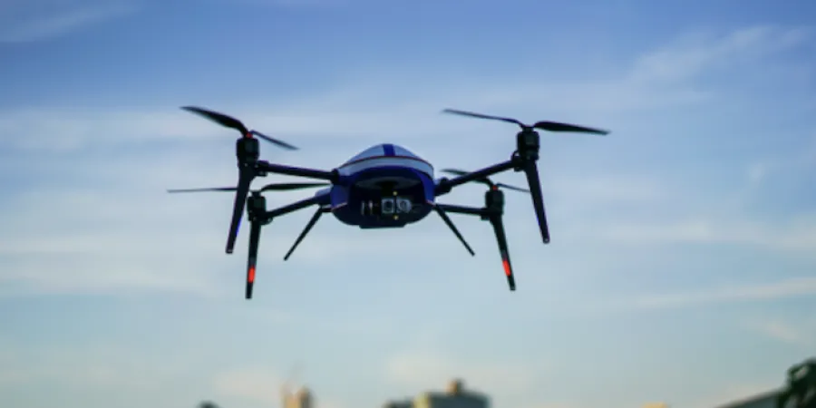
Photo: Easy Aerial website
The Israeli companies infiniDome and Easy Aerial, together with American Honeywell, demonstrated during November 2021 their UAV-tailored resilient navigation solution to complete critical missions under GPS challenged and denied environments.
According the companies' announcement, the three parties demonstrated the fully operational Robust Navigation System, which integrates GPS anti-jamming technology (GPSdome), Inertial System (NCINS) and Radar Velocity System (HRVS) into the first-ever fully resilient navigation system allowing UAVs not only to stay in the sky but actually complete their mission.
Unmanned Aerial Vehicles (UAVs) rely almost entirely on GNSS (Global Navigation Satellite System) for basic navigation, particularly for BVLOS (Beyond Visual Line Of Sight) and autonomous operations. Due to the weakness of GNSS signals, UAVs are extremely susceptible to jamming attacks, which can be carried out from large distances using cheap jammers bought online.
The Robust Navigation System, jointly developed by Honeywell and infiniDome, solves the above-mentioned problem by tightly pairing GNSS-based UAV-tailored Honeywell Compct Inertial NAvigation System (HCINS) with infiDome's GPS anti-jamming technology (GPSdome), integrated with Honeywell’s Radar-based Velocity System (HRVS). The Robust Navigation System is a one-stop shop that can be installed on almost any UAV with a common flight controller (e.g. PixHawk) providing it with continuous, accurate navigation data in GNSS-challenged or fully GNSS-denied environments.
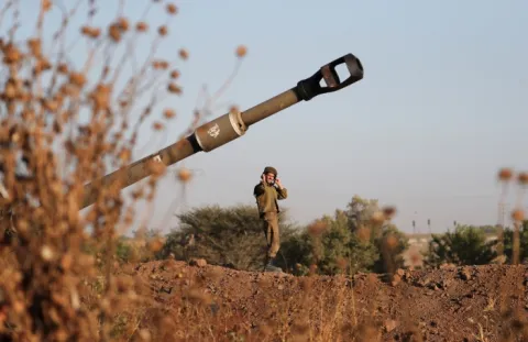
The main goal for the demo was to prove the Robust Navigation System capabilities in maintaining autonomous navigation operation for multi-copters under different GPS/GNSS jamming scenarios. The testing was set up at the testing range in the center of Israel where 2 military-grade directional jammers (different types & bandwidths) were used to jam the navigation system of an Easy Aerial Osprey Hexa-copter operating with a PixHawk 2.1 Cube Black.
The companies say that the purpose of the test was to show that a UAV protected by the Robust Navigation System, under a GPS challenged environment (single direction of jamming) and fully denied environment (multiple directions of powerful jamming by military-grade jammers) can perform BVLOS and autonomous tasks accurately and safely without needing to assume manual control of the UAV. According to the parties involved, the test displayed and recorded that the UAV, protected by the Robust Navigation System solution, passed all planned tests and proved that in a GNSS-challenged environment and even in full GNSS-denied environment, the UAV can not only safely land or return home, it can complete its BVLOS / Autonomous mission.
The test also showed that an unprotected drone, when attacked by the same jammers, within 3-5 seconds loses position accuracy and GNSS fix, tilts at an aggressive angle and takes off in seconds in a random direction. The only way to avoid it drifting kilometers away and eventually crashing is by taking manual control and visually bringing it back.
The three companies demonstrated the Robust Navigation System, which integrates GPS anti-jamming technology Inertial Systems and Radar Velocity System into their fully resilient navigation system, allowing UAVs not only to stay in the sky but to actually complete their mission
Photo: Easy Aerial website
The Israeli companies infiniDome and Easy Aerial, together with American Honeywell, demonstrated during November 2021 their UAV-tailored resilient navigation solution to complete critical missions under GPS challenged and denied environments.
According the companies' announcement, the three parties demonstrated the fully operational Robust Navigation System, which integrates GPS anti-jamming technology (GPSdome), Inertial System (NCINS) and Radar Velocity System (HRVS) into the first-ever fully resilient navigation system allowing UAVs not only to stay in the sky but actually complete their mission.
Unmanned Aerial Vehicles (UAVs) rely almost entirely on GNSS (Global Navigation Satellite System) for basic navigation, particularly for BVLOS (Beyond Visual Line Of Sight) and autonomous operations. Due to the weakness of GNSS signals, UAVs are extremely susceptible to jamming attacks, which can be carried out from large distances using cheap jammers bought online.
The Robust Navigation System, jointly developed by Honeywell and infiniDome, solves the above-mentioned problem by tightly pairing GNSS-based UAV-tailored Honeywell Compct Inertial NAvigation System (HCINS) with infiDome's GPS anti-jamming technology (GPSdome), integrated with Honeywell’s Radar-based Velocity System (HRVS). The Robust Navigation System is a one-stop shop that can be installed on almost any UAV with a common flight controller (e.g. PixHawk) providing it with continuous, accurate navigation data in GNSS-challenged or fully GNSS-denied environments.
The main goal for the demo was to prove the Robust Navigation System capabilities in maintaining autonomous navigation operation for multi-copters under different GPS/GNSS jamming scenarios. The testing was set up at the testing range in the center of Israel where 2 military-grade directional jammers (different types & bandwidths) were used to jam the navigation system of an Easy Aerial Osprey Hexa-copter operating with a PixHawk 2.1 Cube Black.
The companies say that the purpose of the test was to show that a UAV protected by the Robust Navigation System, under a GPS challenged environment (single direction of jamming) and fully denied environment (multiple directions of powerful jamming by military-grade jammers) can perform BVLOS and autonomous tasks accurately and safely without needing to assume manual control of the UAV. According to the parties involved, the test displayed and recorded that the UAV, protected by the Robust Navigation System solution, passed all planned tests and proved that in a GNSS-challenged environment and even in full GNSS-denied environment, the UAV can not only safely land or return home, it can complete its BVLOS / Autonomous mission.
The test also showed that an unprotected drone, when attacked by the same jammers, within 3-5 seconds loses position accuracy and GNSS fix, tilts at an aggressive angle and takes off in seconds in a random direction. The only way to avoid it drifting kilometers away and eventually crashing is by taking manual control and visually bringing it back.